

Author: Ivica Pavičić, PhD., Postdoctoral researcher
One of the most common challenges of geological exploration is reconstructing underground geological settings based on surface data. When conducting such research, collecting as much data as possible from the surface is important to reconstruct the subsurface geological settings more realistic and precise. This is often the case when investigating rock discontinuities (bedding, fractures, etc.). The fracture orientation data can be collected in different ways: from the drill hole cores, the optical and acoustic televiewer survey, drill hole geophysics, and drill hole camera surveying. The best way to observe and measure fracture system parameters (orientation, density intensity, cross-cutting relations etc.) is in open pits, outcrops, and road cuts. When it is impossible to obtain the fracture data from the terrain, the only alternative option is to obtain them underground by drilling.
The investigated area was located on the E side of Pelješac Peninsula, not far from Osobjava Village. Since terrain in our research area was impassable and had vegetation cover, and other drill hole analyses (geophysical, optical, and acoustic televiewer logging methods) were relatively expensive for the investor, especially in the initial, “pre-quarry” phase of the research, improvisation was needed to find a relatively affordable way to measure the discontinuities orientation in the drill holes. Given that the discontinuity orientations in the subsurface are one of the basic data, especially in the preliminary exploration for many further analyses, the team of scientists from the RGN faculty (Ph.D. Ivica Pavičić and Prof. Ivo Galić, Ph.D.) and Perica Vukojević, M.Sc., director of Hidro-geo projekt d.o.o. have developed an innovative and relatively affordable way of discontinuity orientation survey in boreholes using a borehole camera. The results of these investigations were published in 2020 in the scientific journal Applied Sciences: Fracture System and Rock-Mass Characterization by Borehole Camera Surveying: Application in Dimension Stone Investigations in Geologically Complex Structures.
Figure 1. Graphical abstract – photos of the borehole and from them derived orientation data for one of the set of discontinuities.
Based on the drill hole position and the drill hole core logs, six drill holes were chosen for survey by the drill hole camera. We used a drill hole camera system with spatial orientation of the bottom and side camera (Figure 1-3, Figure 5). The borehole camera was transported by terrain vehicle to the drill hole location (Figure 5). The camera was then centered above the drill hole by the tripod, and the depth was set to zero m. Camera orientation was checked (on each drill hole) while the camera was still at the surface.
A fracture surface is a three-dimensional plane in space with two main characteristics: dip direction and dip angle. Each fracture is measured manually in four points (Figure 2) by down and side cameras to define fractures in space adequately. First, from the bottom camera we defined the strike and azimuth of the fracture, which is then checked and improved by the side camera (Fig 4A, C, D, E, F). Dip angles were also checked on the drill hole cores for higher measurement precision. The whole surveying was recorded so later interpretation, reinterpretation, and validation could be made.
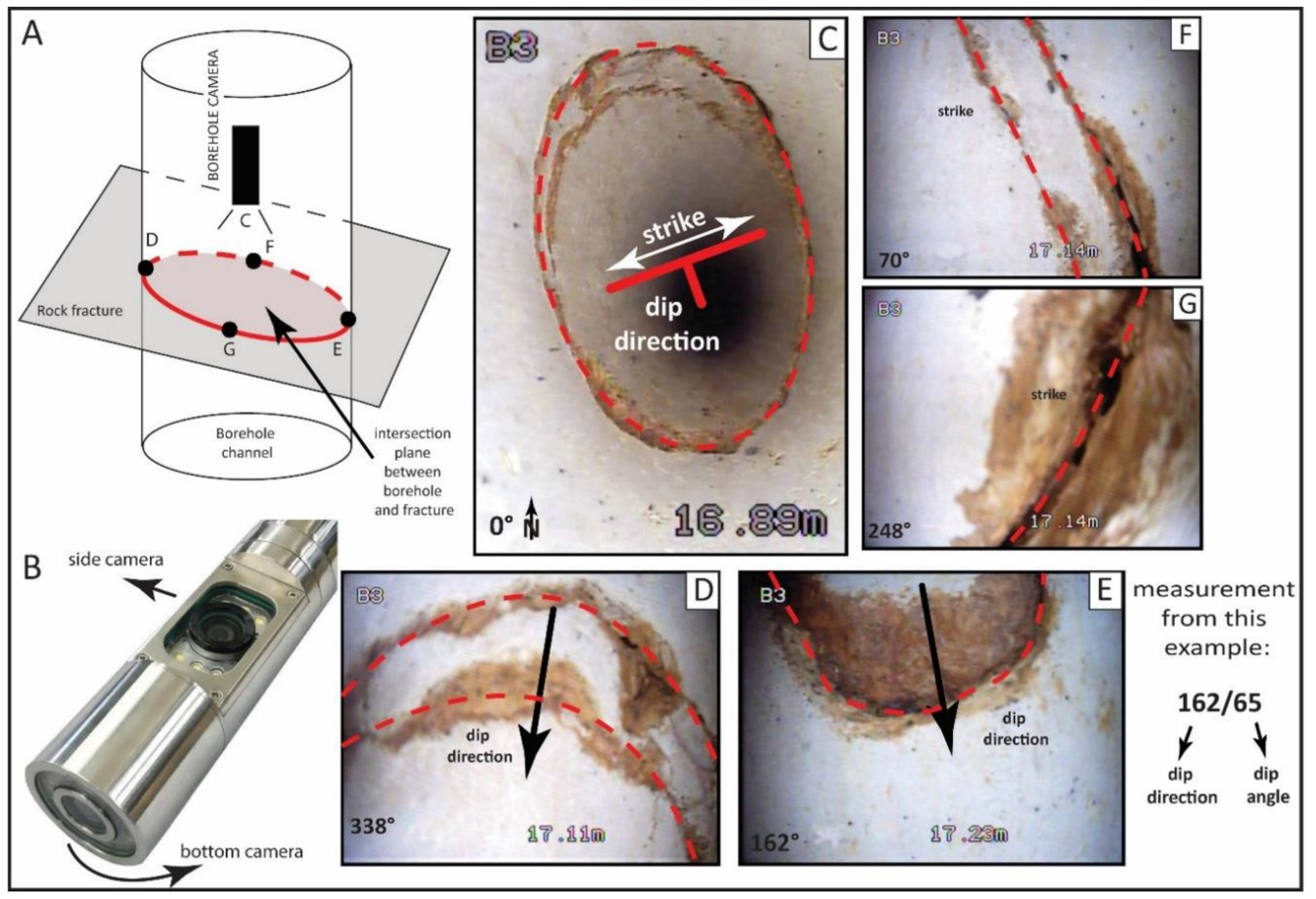
Figure 2. A) Relationship between the cross-section of the borehole and the rock discontinuity B) Borehole camera; C) Vertical image of the borehole, D, E, F, G) Side shot of the borehole and crack trace (Pavičić et al., 2020).
In conditions where it is impossible to collect enough data from the surface, borehole camera surveys and derived interpretations and analyses (Figure 4) provide a solid basis for making decisions for further investment plans and the dimension stone exploitation type.
Through the borehole camera survey, it is possible to visualize rock mass in the borehole and measure the characteristics of fractures and fracture systems. The achieved results and conclusions are as follows: (1) Borehole camera survey enables fast, efficient, and relatively affordable geological research of fracture systems and the state of the rock mass; (2) statistical parameters of fracture distribution, fracture orientation, fracture set delineation, P10, aperture, Volumetric Joint Count (Jv) (Figures 3 and 4)...
Table 1. Objectives and possibilities of the method of recording discontinuities with a borehole camera.
|
Goals |
Possibilities |
|
Recording of discontinuity features in boreholes |
Vertical boreholes up to 300 m, dry and with water
|
|
Determination of the mathematical distribution of orientations of discontinuities Determination of spatial parameters of sets of discontinuities (sets, orientations of individual sets, line density/intensity (P10), the distance of discontinuities |
Videos of each survey |
|
Determination of the mathematical distribution of discontinuity orientations |
Determining the state of boreholes, locations of damages and/or deformations |
|
Statistical estimates of the volumetric number of cracks (Jv) and the shape and size of the expected block |
Depth to the water determination |
|
Based on the relationship between discontinuity orientation and stress field orientation, geological structure interpretation |
Determining the depth and orientation of cave spaces and caverns and estimating their size |

Figure 3. Diagram showing the block size distribution in the rock mass and types of blocks in the rock mass (Palmstrom, 2001)
The presented methodology is an innovative, relatively fast, and low-cost method that gives solid input on the state of the investigated rock mass, bedding orientation, degree of jointing, and preliminary block size estimation, which is very important for decision making in the initial phase of quarry investment, since these factors control the potential of the location for dimension stone deposit and type of excavation. The methodology is also applicable in the hydrogeological (fractured aquifers), geotechnical, civil engineering, and engineering geology research (rockfalls, construction of roads, viaducts, railways, bridges, tunnels, etc.), where knowledge about fracture systems in the rock mass is crucial for further works.

Figure 4. A) Sets of discontinuities obtained by borehole camera measurements and correlation with the position within the geological structure to define the parameters of exploitation of a potential quarry on Pelješac (Pavičić et al., 2020)

Figure 5. Field recordings of the conducted measurements.
References:
- Palmström, A. Measurement and characterizations of rock mass jointing. In In-Situ Characterization of Rocks; CRC Press/Balkema: Leiden, The Netherlands, 2001; pp. 1–40.
- Pavičić, Ivica, Ivo Galić, Mišo Kucelj, and Ivan Dragičević. 2021. "Fracture System and Rock-Mass Characterization by Borehole Camera Surveying: Application in Dimension Stone Investigations in Geologically Complex Structures" Applied Sciences 11, no. 2: 764. https://doi.org/10.3390/app11020764
Ivica Pavičić, Ph.D. is a Postdoctoral Researcher at the Department of Geology and Geological Engineering at the Faculty of Mining, Geology and Petroleum, University of Zagreb. He received his Ph.D. on July 12, 2018. with a doctoral thesis entitled: Origin, spatial distribution, and quantification of porosity in Upper Triassic dolomites in Žumberak Mts.
E-portfolio https://moodle.srce.hr/eportfolio/view/view.php?id=32388
ResearchGate https://www.researchgate.net/profile/Ivica-Pavicic-2
Google Scholar https://scholar.google.hr/citations?user=nAhx3kYAAAAJ&hl=hr&oi=ao
CROSBI https://www.bib.irb.hr/pretraga?operators=and|Pavi%C4%8Di%C4%87,%20Ivica%20%2833346%29|text|profile